
Tags
Still reeling and trying to internalize the events from my last trip to El Gadarif and the Ethiopian border, I got the chance to go to the tiny island of Arnata, where my mother’s family is from. It was an opportunity I had been chasing for sometime but lacked the motivation as no one was keen on accompanying me. Luckily for me my aunt had a preplanned trip to the region to report on the progress of the Al Seleim-7alfa-Gustul, Egypt road that is currently in development. I jumped at the chance and packed my bags within hours of the news eagerly anticipating the journey. To give you an idea of the regions traversed during this trip, take a look at the map below:
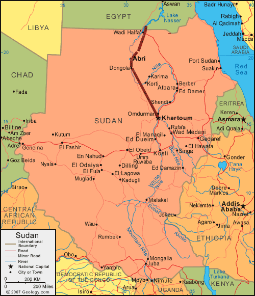
The first leg of the journey from Khartoum to Dongola (roughly 500km) was a breeze thanks to a relatively new paved highway that connects the 2 cities. The five hour journey led us into Dongola right around lunch time. We made a pit stop to eat, rest and accompany my aunt on some work related meetings. Up until this point the topography of the region validated my mental image of the deserts of northern Sudan. Large breaks of sandy dunes with a solemn mountain/ rock formation in the distance. For the most part it resembled regions of River Nile State, similar to what I saw along the way to my trip to Abu Hamad. (and the island of Mougrat). The paved road passed Dongola extends a few more kilometers to cover Al-Seleeim region. Beyond that point we entered new territory.
I was taken aback by the city of Dongola. To be honest I really didn’t expect it to resemble a city at all but instead had the image of a large village in mind. I was pleasantly surprised to enter a meticulously organized city with particular care from local authorities to keep the maintain the greenery that adorned its streets. My stay in Dongola was brief, so there isn’t much I can say about the people as I did not have much time for interaction.
